Pilgrim Mine - History
The Pilgrim Mine Site is the site of a former gold mine that occupies approximately 12 acres of land located 21 miles north of Kingman, Arizona and 10 miles west of the town of Chloride, AZ. An image of the site within Arizona is shown in Figure 1.1, below. The site was previously operated under the name of the Pioneer Gold Mining Co., Mine, the Katherine Treasure Vault Mine and the Al Smith Producer Mill Mine. Flotation mills, cyanidation, heap leaching, tank leaching carbon-in-pulp, and carbon-in-leach are methods that were previously used at the site The site now has three tailing piles that may have migrated off site from percipitation or wind.
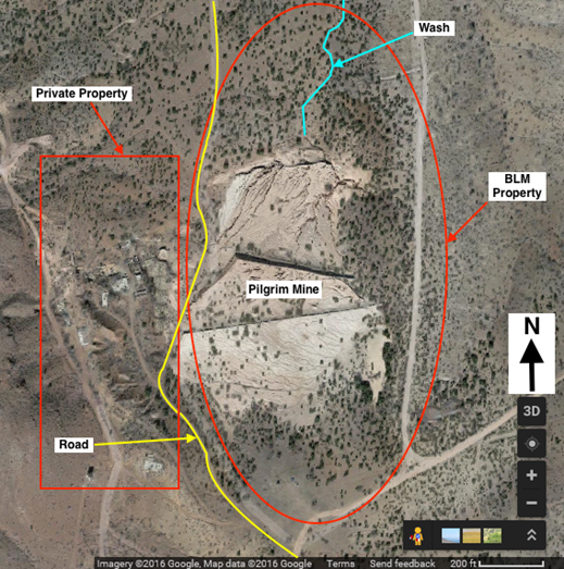
The area is presently utilized for recreational use and neighbors ranching lands. The mine poses a potential threat to human and ecological health as contaminants are left open to the public and migration away from the site is slowly occurring. The mine site consists of three separate tailings piles and a wash located north of the tailings pile, which runs north, away from the tailings piles. Soil samples were collected from the specified areas of concern using a gridded system for the tailings piles, as well as transects along the wash (perpendicular to the wash’s trajectory). Gridded and transect sampling was used to ensure unbiased sampling, as well as establishing the extent of the contamination. Hot spot or high concentration samples were taken in the wash when visible tailings were observed. Lastly, background samples were taken of native, undisturbed soils to the south and north of the site to determine the natural concentration of contaminants in the soil.
The samples were analyzed to identify the contaminants of concern, their corresponding concentrations, and to determine if any migration is occurring away from the site. The Figure below shows a map of the Pilgrim Mine Site.
Work Plan
On December 19th, 2016, Ecovestor completed a Work Plan for the Pilgrim Mine Site. The work plan specified field sampling procedures and rationale, as well as the soil testing techniques that will be completed in the laboratory. The Work Plan includes a Health and Safety Plan (HASP) and a Sampling and Analysis Plan (SAP). The Work Plan is included in the sidebar links.
Field Sampling
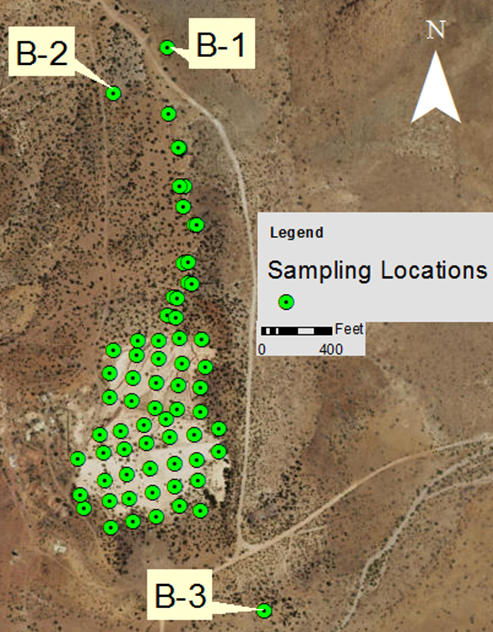
On January 27, 2017, at approximately 10:30 in the morning the field sampling began with five technicians: two technicians used the GPS and 100-ft measuring tape to flag pre-determined data points; while the other three technicians prepared the decontamination station and began sampling flagged points. Two technicians collected soil samples, while the third recorded observations and provided direction to the soil samplers. The Figure below shows the locations of each sample taken. To distinguish between tailings piles they were given names based on their location: north, central and south tailings pile. The gird system for the three tailings pile were gridded out to provide an even distribution of samples for the north, central and south tailing piles. The grid template used during sampling is located in the Work Plan.
Contaminants of Concern
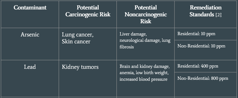
After the soil samples have been analyized the contaminants at the site were identified. The table below identifies the Arizona Residential and Non-Residential Soil Remediation Standards for each contaminant. The health risks for each contaminate is also listed.
Spatial Distribution of Contaminant Concentrations
The Figure below and to the left identifies arsenic data points. The yellow and red points are above the residential and non-residential standards respectively. The majority of the samples are in the range of 10 to 500 mg/kg of arsenic. A smaller portion of samples are above 500 mg/kg and of those samples, the majority are located to the south. The southernmost tailings pile is the newest and has less weathering. The rest of the high arsenic values are located near exposed tailing crevasses, created from water flow and wind erosion.
The background samples (B-2 and B-3) were above 10 mg/kg soil standard but their values were 26.1 and 14.5 mg/kg respectively. It is unlikely that the tailings would have travelled off site to the extent of contaminating background soils both north and south of the site. This indicates that the site may have naturally high arsenic concentrations.
The Figure above and to the right identifies arsenic data points. The yellow and red points are above the residential and non-residential standards respectively. The majority of the samples are in the range of 10 to 500 mg/kg of arsenic. A smaller portion of samples are above 500 mg/kg and of those samples, the majority are located to the south. The southernmost tailings pile is the newest and has less weathering. The rest of the high arsenic values are located near exposed tailing crevasses, created from water flow and wind erosion. The background samples (B-2 and B-3) were above 10 mg/kg soil standard but their values were 26.1 and 14.5 mg/kg respectively. It is unlikely that the tailings would have travelled off site to the extent of contaminating background soils both north and south of the site. This indicates that the site may have naturally high arsenic concentrations
Risk Assessment
Adult Cancer Risk
Child (6-12) Cancer Risk
Child (2-6) Cancer
 cancer risk.png)
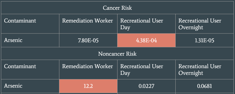
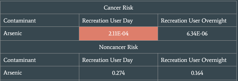
Cancerous risk is measure by the likelihood of how many people out of a population equally exposed to a contaminant would contract cancer is exposed over a period of 70 years. The acceptable cancer risk set by the EPA is less than 1 in 10,000 people which in scientific notation is equivalent to 1E-4 anything above this number is considered unacceptable risk and anything below this number is considered acceptable. While the EPA guidelines are standard a specific site can have stricter guidelines for acceptable cancer risk. Non-cancerous risk was measured using a hazard index. The hazard index measures the ratio of potential exposure to the substance and the level at which no adverse effects are expected. Anything above a value of one is considered unacceptable risk and anything below one is considered acceptable risk.
The lead risk found none of the exposure scenarios exceeded the level of concern. The analysis is available in the PA/SI link in the side bar.
Recommendations
Ecovestor would recommend that the site be analyzed further for arsenic risks. From our analysis, the site posed the highest risk to humans from the arsenic concentration. We would also recommend taking both water and air samples. The water samples should be taken from local wells and open water stations adjacent to the site. These samples could than help to determine new exposure scenarios for humans and animals on site. At this time, Ecovestor cannot recommend remediation of the site since the analysis completed was field screening level.

